


Nestled between two of Oregon’s most significant waterways—the mighty Willamette River to the east and the winding Tualatin River to the north—Wilsonville enjoys a picturesque setting that defines its character and community. However, this unique geographic position also presents distinct challenges when heavy rains arrive in the Pacific Northwest.
At Pacific Water & Fire Restoration, we’ve worked with numerous Wilsonville property owners to prevent, mitigate, and recover from flood damage. This experience has given us valuable insights into the specific challenges this community faces and the most effective strategies for protecting homes and businesses in this distinctive riverside environment.
Understanding Wilsonville’s Unique Flood Risk Profile
Wilsonville’s flood risk stems from multiple factors that combine to create a complex hydrological situation unlike many other Portland suburbs.
The Two-River Challenge
The Willamette River, which forms Wilsonville’s eastern boundary, drains approximately 11,478 square miles—roughly 12% of Oregon’s total area. Meanwhile, the Tualatin River, defining much of the northern edge of the city, serves as the primary drainage system for Washington County before joining the Willamette just east of Wilsonville.
This positioning creates a potential “pincer effect” during major storm events:
- Heavy rainfall throughout the Willamette Valley can raise the Willamette River levels
- Simultaneous rainfall in Washington County increases Tualatin River flow
- When both rivers rise concurrently, Wilsonville can face pressure from two directions
Local Topography Factors
Wilsonville’s varied elevation adds another layer of complexity:
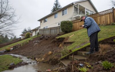
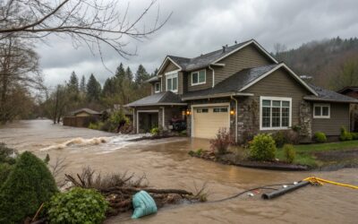
- Riverfront Areas: Properties along both rivers sitting at lower elevations face the most direct risk
- Charbonneau District: This neighborhood south of the Willamette River is particularly vulnerable due to its lower elevation and limited drainage options
- Central Wilsonville: Though at higher elevation, this area can experience localized flooding during extreme precipitation due to stormwater system capacity limitations
- Creek Tributaries: Smaller waterways like Coffee Creek and Boeckman Creek can overflow during heavy rains, affecting neighborhoods not directly adjacent to the main rivers
Historical Context
According to the National Oceanic and Atmospheric Administration (NOAA), Wilsonville has experienced significant flooding events approximately once every 7-10 years. Notable flood events include:
- The February 1996 Willamette Valley Flood, which caused widespread damage throughout the region
- December 2008 flooding, when heavy snow followed by warm rain created rapid runoff
- January 2012 flooding along the Tualatin River affecting northern Wilsonville
Pro Tip: Residents can check current river levels and forecasts for both the Willamette and Tualatin Rivers through the National Weather Service’s Advanced Hydrologic Prediction Service online. This free resource provides real-time data and projected river stages that can provide critical advance warning.
Flood Prevention and Preparation for Wilsonville Properties
Being prepared for potential flooding requires understanding your specific property’s vulnerabilities and taking appropriate preventative measures.
Know Your Flood Zone
The first step in flood preparation is understanding your property’s official flood risk designation:
- FEMA Flood Insurance Rate Maps (FIRMs) designate properties into different flood risk zones
- Properties in “Special Flood Hazard Areas” (Zones A and AE in Wilsonville) have a 1% or greater annual chance of flooding
- Properties in “Zone X” have reduced risk but are not immune to flooding, especially in Wilsonville’s unique two-river environment
- Wilsonville properties in Clackamas County can check their flood zone designation through the county’s GIS mapping system
According to Clackamas County Emergency Management, approximately 15% of Wilsonville properties lie within designated Special Flood Hazard Areas, but historical flooding has affected properties outside these officially designated zones.
Property-Level Prevention Measures
Water Barrier Systems
Modern flood prevention technology offers several options for Wilsonville homeowners:
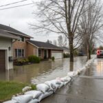
- Flood panels: Removable barriers that can be installed across doorways, windows, and garage doors when flooding threatens
- Sandbags: Traditional but effective temporary barriers (the City of Wilsonville often provides filling stations during flood threats)
- Inflatable flood barriers: Newer technology that creates water-filled dams around properties
- Permanent flood walls: For properties with recurring issues, permanent barriers with removable closure systems
Drainage Improvements
Proper drainage is critical, especially for properties in central Wilsonville where stormwater management is the primary concern:
- Install and maintain French drains around your property perimeter
- Ensure downspouts direct water at least 10 feet from your foundation
- Consider a sump pump system with battery backup for basements and crawlspaces
- Keep gutters and nearby storm drains clear, especially during fall leaf drop
Landscape Modifications
Strategic landscaping can significantly reduce flood vulnerability:
- Create swales and rain gardens to direct water away from structures
- Use permeable paving for driveways and patios to increase ground absorption
- Plant native vegetation with strong root systems that can help manage erosion, especially on riverfront properties
- Grade your yard to channel water away from your foundation and toward appropriate drainage
Safety Warning: Never attempt to drive through flooded roadways. According to the National Weather Service, just 12 inches of moving water can carry away a small car, while 18-24 inches can sweep away larger vehicles. Wilsonville’s proximity to two rivers means road flooding can happen quickly and with significant force.
Community Resources and City Initiatives
Wilsonville has implemented several measures to address its unique flooding challenges:
Stormwater Management System
Wilsonville maintains an extensive stormwater management system designed with its two-river geography in mind:
- The city’s network includes over 87 miles of storm sewers
- More than 120 stormwater detention facilities help manage heavy rainfall
- Regular maintenance schedules prioritize clearing before the rainy season
- Recent infrastructure improvements have focused on upgrading capacity in historically vulnerable areas
Emergency Response Planning
The city has developed specific flood response protocols:
- Designated evacuation routes away from both river corridors
- Emergency shelter locations at Wilsonville High School and Town Center Park
- Early warning systems integrated with Clackamas County Emergency Management
- Mutual aid agreements with neighboring communities for resource sharing
Community Education
Wilsonville offers resources to help residents prepare for and respond to flooding:
- Annual preparedness workshops, typically held in September before the rainy season
- The Wilsonville CERT (Community Emergency Response Team) program trains volunteers in disaster response
- The city’s website provides downloadable flood preparation checklists and emergency contact information
- Public Works Department staff can provide property-specific consultation for flood mitigation
Case Study: Charbonneau District’s Community Approach
The Charbonneau District, situated on a peninsula formed by a bend in the Willamette River, has developed a particularly effective community-based approach to flood management:
- Community-Wide Planning: After experiencing significant impacts during the 1996 floods, the Charbonneau Country Club homeowners association developed a comprehensive flood response plan.
- Equipment Sharing: The community maintains a shared inventory of pumps, generators, and flood barriers that can be quickly deployed to the most vulnerable areas.
- Buddy System: Residents participate in a “flood buddy” program where neighbors check on each other during flood threats, with special attention to elderly or disabled residents.
- Communication Network: A dedicated phone tree and text alert system ensures rapid dissemination of information during flood events.
- Regular Drills: Annual practice sessions ensure all residents know evacuation routes and emergency procedures.
This coordinated approach has significantly reduced flood damage during subsequent high-water events, demonstrating how community-level organization can complement individual property measures.
When Waters Rise: Emergency Response and Recovery
Despite the best preventative efforts, flooding can still occur, especially during extreme weather events. Knowing how to respond can significantly reduce damage and recovery time.
Immediate Response During Flooding
If flooding threatens or begins to affect your property:
- Safety First:
- Turn off electricity at the main breaker if water threatens electrical systems
- Evacuate if instructed by authorities or if water levels make staying dangerous
- Avoid contact with floodwater, which may contain contaminants or debris
- Documentation:
- Take photos and videos of conditions if safe to do so
- Note the time flooding began and water rise patterns
- Document all emergency measures taken
- Emergency Measures:
- Deploy any available flood barriers
- Move valuable items to higher levels
- Use pumps if available and safe to operate
The Recovery Process
At Pacific Water & Fire Restoration, we follow a comprehensive approach to flood recovery tailored to Wilsonville’s specific challenges:
- Water Extraction: Using industrial-grade pumps and extraction units designed for the particular type of flooding (river water vs. stormwater)
- Contamination Assessment: Wilsonville’s flooding often involves river water, which requires testing for contaminants specific to the Willamette and Tualatin Rivers
- Structural Drying: Utilizing specialized equipment to thoroughly dry all affected areas, preventing secondary damage like mold growth
- Sanitization: Applying appropriate antimicrobial treatments based on the flood source and contamination level
- Restoration Planning: Developing a comprehensive plan to restore your property to pre-flood condition, often coordinating with other specialists for major repairs
Pro Tip: Create a dedicated “flood box” with important documents in waterproof containers, emergency contact information, essential supplies, and a home inventory list with photos. Store this in an easily accessible location above potential flood levels.
Insurance Considerations for Wilsonville Property Owners
Understanding flood insurance options is particularly important for Wilsonville residents due to the community’s unique two-river flood risk profile:
- Standard homeowners and business insurance policies typically do not cover flood damage
- National Flood Insurance Program (NFIP) policies are available to all Wilsonville residents, regardless of flood zone
- Properties in Special Flood Hazard Areas with federally-backed mortgages are required to have flood insurance
- Even properties outside designated flood zones should consider coverage due to Wilsonville’s unique geographic position
- There is typically a 30-day waiting period before new flood insurance policies take effect
According to FEMA, the average flood insurance claim payment in Oregon is approximately $27,000, while the average annual premium in moderate to low-risk areas ranges from $400-$600. For Wilsonville specifically, premiums vary significantly based on exact location, elevation, and property characteristics.
Climate Change Implications for Wilsonville
Climate change projections suggest Wilsonville may face increased flooding challenges in coming decades:
- The National Climate Assessment projects that winter precipitation in the Pacific Northwest will increase by 5-15% by mid-century
- More precipitation is expected to fall as rain rather than snow in the Cascade Mountains, potentially increasing winter and early spring river flows
- More intense rainfall events may challenge Wilsonville’s stormwater management system
- Sea level rise will eventually impact the lower Willamette River, potentially affecting flood patterns as far upstream as Wilsonville during extremely high tides combined with flooding
These projections underscore the importance of long-term planning and investment in both property-level and community-wide flood resilience measures.
Conclusion: Building a Flood-Resilient Wilsonville
Living between two rivers presents both opportunities and challenges for Wilsonville residents. The community’s approach to flood management demonstrates how understanding specific local conditions, implementing appropriate preventative measures, and preparing for emergencies can create resilience even in geographically vulnerable areas.
At Pacific Water & Fire Restoration, we’re committed to helping Wilsonville property owners navigate the unique challenges of this two-river environment—both in preventing flood damage and providing expert restoration services when needed.
Take Action Today
Don’t wait until the forecast calls for heavy rain to address potential flood vulnerabilities:
- Emergency Response: For immediate flood damage, call our 24/7 emergency line at 503-201-7337
- Preventative Assessment: Schedule a free property evaluation to identify potential vulnerabilities and develop mitigation strategies
- Restoration Consultation: If you’ve experienced flooding in the past, our specialists can help identify and address underlying issues to prevent future damage
Remember, in Wilsonville’s unique environment between the Willamette and Tualatin Rivers, proactive flood management isn’t just about protecting your property—it’s about preserving the riverside lifestyle that makes this community special.
Pacific Water & Fire Restoration serves the entire Portland metro area, including Wilsonville, Tualatin, West Linn, and surrounding communities. Our IICRC-certified professionals are available 24/7 for emergency response to water, fire, mold, and storm damage. Contact us at 503-201-7337 or visit our website to learn more about our comprehensive restoration services.