
Introduction: Molalla’s Unique Geographic Challenges
Situated where the dense forests of the Cascade foothills transition into the rich agricultural lands of the Willamette Valley, Molalla, Oregon occupies a geographic transition zone that makes it particularly vulnerable to dual natural disaster threats. To the east, the heavily forested slopes create significant wildfire risk during increasingly dry summers, while the Molalla River and its tributaries present flooding challenges during intense winter precipitation events. This distinctive geography creates a community that must be equally prepared for fire and water—two opposing forces that require very different prevention, preparation, and recovery strategies.
At Pacific Water & Fire Restoration, we’ve worked extensively with Molalla residents and businesses to address these complementary risks. Our experience has given us unique insights into how this community has developed innovative approaches to managing these contrasting threats. Through thoughtful planning, community cooperation, and strategic investment, Molalla has created a model for disaster resilience that addresses multiple hazards simultaneously.
This blog explores Molalla’s dual-threat approach, offering valuable insights for property owners throughout the Portland metro area who face similar challenges, whether from seasonal flooding, increasing wildfire risks, or both.
Understanding Molalla’s Geographical Risk Profile
The Forest-Valley Interface
Molalla sits at what emergency management professionals call a “multi-hazard interface”—a location where different geographical features create overlapping disaster risks. This interface creates several distinctive challenges:
- Wildland-Urban Interface (WUI) – Eastern Molalla transitions into densely forested areas where homes intermingle with natural vegetation, creating prime conditions for wildfire spread
- Riparian Flood Zones – The Molalla River and its tributaries create extensive flood plains that affect significant portions of the community
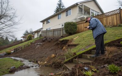
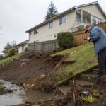
- Slope Dynamics – The transition from foothills to valley creates areas with erosion and landslide potential, particularly after wildfires or during heavy precipitation
- Wind Channel Effects – The topography can funnel both east winds (increasing fire danger) and west winds (bringing heavy precipitation)
- Soil Composition Variations – Different soil types across the region affect both fire spread patterns and flooding/drainage characteristics
According to data from the Oregon Department of Forestry, approximately 40% of Molalla properties are within the Wildland-Urban Interface, while Clackamas County flood maps indicate about 15% of properties have some level of flood risk. Most significantly, about 10% of properties face both threats, requiring particularly nuanced preparation approaches.
Climate Factors Intensifying Both Threats
Recent climate trends have intensified both wildfire and flooding risks for Molalla. Key patterns include:
- Longer, Drier Summers – Extended dry periods create more severe wildfire conditions
- More Intense Precipitation Events – Heavier rainfall episodes increase flash flooding potential
- Earlier Snowmelt – Changes in spring runoff patterns affect river levels and soil moisture
- More Frequent Weather Extremes – Greater oscillation between wet and dry periods
- Vegetation Changes – Shifting plant communities due to changing conditions
Data from Oregon State University’s Climate Research Center indicates the Molalla area has experienced a 15% decrease in summer precipitation and a 12% increase in winter precipitation intensity over the past 30 years. These trends are projected to continue, potentially intensifying both threat profiles.
Historical Events That Shaped Molalla’s Approach
Several significant events have influenced Molalla’s current dual-threat management strategy:
- 1996 Willamette Valley Floods – While not directly on the Willamette, the Molalla River experienced major flooding that affected significant portions of the community
- 2009 Deer Creek Fire – Burned over 1,000 acres just east of Molalla, coming within two miles of city limits
- 2020 Riverside/Dowty Road Fires – Part of the catastrophic Labor Day fires, these threatened Molalla directly, forcing full community evacuation
- 2021 Atmospheric River Flooding – Intense rainfall caused significant flooding along the Molalla River and its tributaries
Each of these events revealed specific vulnerabilities and prompted community response innovations. The proximity of the 2020 wildfires, in particular, transformed Molalla’s approach to emergency management, highlighting the need for comprehensive preparation for multiple, potentially simultaneous threat scenarios.
Molalla’s Integrated Wildfire Management Strategy
Community-Wide Defensible Space Initiatives
Molalla has developed a distinctive approach to wildfire mitigation that extends beyond individual property boundaries to create community-scale defensible space:
- Neighborhood-Level Fuel Reduction – Coordinated vegetation management across property lines
- Strategic Fuel Breaks – Creating maintained areas that can slow or stop fire spread, particularly on the eastern edge of the community
- Common Area Management Standards – Special requirements for homeowners associations and shared spaces
- Roadside Clearing Programs – Maintaining evacuation routes with enhanced vegetation management
- Green Space Fire Adaptation – Redesigning parks and public areas to reduce fire spread potential
The Molalla Fire District coordinates an annual “Fire-Safe Community Day” where volunteers help vulnerable residents with defensible space maintenance. This program has created defensible space for over 200 properties since its inception in 2018.
Pro Tip: Molalla residents can request a free defensible space assessment from the Molalla Fire District. These assessments identify property-specific vulnerabilities and recommend prioritized improvements. Contact the fire district’s prevention office to schedule.
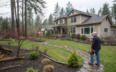
Property-Specific Prevention Measures
For individual properties, particularly those in the Wildland-Urban Interface areas east of town, specific protection measures have proven effective:
- Zone-Based Vegetation Management
- Zone 1 (0-5 feet from structures): Nearly vegetation-free with non-combustible materials
- Zone 2 (5-30 feet): Carefully maintained vegetation with significant spacing
- Zone 3 (30-100+ feet): Selective thinning and ladder fuel removal
- Structural Hardening Techniques
- Fire-resistant roofing (Class A rated materials)
- Ember-resistant vents and soffits
- Non-combustible siding or strategic replacement in vulnerable areas
- Multi-pane tempered glass windows
- Deck protection or material upgrades
- Infrastructure Improvements
- Clearly marked addressing for emergency response
- Wide driveways with turnaround areas for fire apparatus
- Secondary water sources for rural properties
- Upgraded electrical connections and maintained power line clearance
According to data collected by the Molalla Fire District, properties implementing comprehensive wildfire protection measures were 80% less likely to sustain damage during wildfire events compared to unprepared properties.
Evacuation Planning and Community Response
Molalla has developed a sophisticated evacuation system following the 2020 wildfire emergency, when the entire community faced evacuation:
Tiered Evacuation Zones – Pre-designated areas with specific evacuation triggers and routes
Early Warning Systems – Multi-channel alert mechanisms including Everbridge notifications, social media, and traditional media
Transportation Assistance Registry – Program identifying residents needing evacuation help
Livestock Evacuation Coordination – Prearranged locations and transportation for large animals
Business Shutdown Protocols – Standardized procedures for commercial operations during evacuations
The community conducts annual evacuation drills for different zones, with participation rates exceeding 40% of households—significantly above the national average for voluntary preparedness exercises.
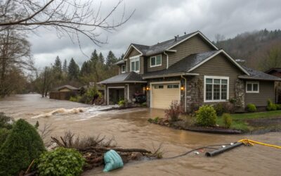
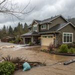
Molalla’s Flood Management Approach
Watershead Management and Natural Systems
While wildfire preparation focuses heavily on the eastern portions of the community, flood management addresses the Molalla River and tributary systems that run through the heart of the area:
- Riparian Buffer Restoration – Enhancing natural vegetation along waterways to slow flood progression
- Detention System Maintenance – Regular clearing and upgrading of natural water detention areas
- Engineered Wetland Preservation – Protecting areas designed to absorb excess water during heavy precipitation
- Stream Channel Maintenance – Strategic removal of blockages that could exacerbate flooding
- Erosion Control Measures – Stabilizing banks in high-risk areas
A partnership between the city, the Molalla River Watch organization, and local landowners has restored over 15 miles of riparian buffer zones since 2010, significantly improving flood resilience in previously vulnerable areas.
Property-Level Flood Protection
For properties in flood-prone areas, particularly in the lower-elevation western portions of the community and along creek corridors, specific protection measures include:
- Structural Elevation – Raising buildings above base flood elevation
- Dry Floodproofing – Sealing structures to prevent water entry up to specific heights
- Wet Floodproofing – Modifying lower areas to allow water entry without significant damage
- Drainage Improvements – French drains, swales, and improved grading to direct water away from structures
- Utility Protection – Elevating electrical systems, HVAC components, and other critical utilities
- Foundation Reinforcement – Strengthening structures to resist flood waters
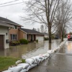
Safety Warning: Never enter a flooded area to retrieve possessions or check on property. Just six inches of moving water can knock an adult off their feet, and floodwaters often contain contaminants and hidden hazards.
Early Warning and Response Systems
Molalla has developed integrated flood monitoring and response systems that leverage both technology and community participation:
- Upstream Monitoring Stations – Providing advance warning of water level changes
- Volunteer Stream Watchers – Designated residents who monitor specific creek sections during heavy rainfall
- Real-Time Alert System – Notifications when key thresholds are reached
- Sandbagging Stations – Pre-positioned supplies activated during flood watches
- Evacuation Triggers – Clear, predefined water level thresholds for evacuation recommendations
The Molalla Public Works Department maintains a text alert system specifically for flood warnings, sending notifications about changing conditions to over 1,500 enrolled residents.
The Confluence: Where Fire and Water Risks Overlap
Post-Wildfire Flooding Challenges
One of the most complex disaster scenarios Molalla prepares for is post-wildfire flooding—when landscapes altered by fire create enhanced flood risks:
- Hydrophobic Soil Conditions – Fire-affected soils that repel rather than absorb water
- Debris Flow Potential – Material from burned areas moving during heavy precipitation
- Reduced Vegetation Absorption – Loss of plants that would normally absorb rainfall
- Channel Blockages – Ash and debris clogging waterways
- Infrastructure Damage – Fire-compromised drainage systems failing during rainfall
Following the 2020 fires, Molalla implemented a specialized post-fire watershed monitoring program that identified several high-risk areas where subsequent heavy rainfall could create flash flooding. This program guided targeted mitigation efforts that successfully prevented major flooding during the heavy rains of late 2020 and early 2021.
Integrated Response Planning
Rather than maintaining separate emergency plans for wildfire and flooding, Molalla has developed an integrated emergency management approach:
- All-Hazard Resource Allocation – Flexible deployment of personnel and equipment based on current threats
- Cross-Trained Response Teams – Emergency personnel prepared for both fire and water emergencies
- Unified Command System – Coordinated management across different types of incidents
- Dynamic Evacuation Routing – Routes that consider both flood and fire scenarios
- Resilient Communications Systems – Multiple redundancies to ensure functioning regardless of disaster type
This integrated approach was tested during a complex 2021 incident when a lightning-caused fire coincided with intense rainfall, creating simultaneous fire and flash flooding threats in different parts of the community. The unified response successfully managed both incidents without loss of life or major property damage.
Multi-Hazard Property Preparation
For Molalla residents, particularly those in areas vulnerable to both threats, property preparation requires a balanced approach:
- Complementary Landscaping Strategies – Designs that create both fire resistance and effective drainage
- Access Considerations – Ensuring emergency access and evacuation routes work for both scenarios
- Building Material Selection – Choosing options resistant to both fire and water damage
- Documentation Redundancy – Securing important records against both threat types
- Insurance Coverage Verification – Ensuring policies address both fire and flood risks
Pro Tip: When designing landscapes for multi-hazard properties, consider “zoned defensible space” that incorporates water management features. For example, rock gardens can serve as both fire breaks and drainage control, while properly spaced fire-resistant trees can help absorb excess groundwater while not contributing to fire spread.
Case Study: The Table Rock Road Community Response
Community Profile and Challenges
The Table Rock Road area east of Molalla provides an excellent case study in multi-hazard management. This rural neighborhood faces distinctive challenges:
- Located in the Wildland-Urban Interface with significant forest coverage
- Crossed by multiple seasonal creeks that flow into the Molalla River
- Limited access routes for both evacuation and emergency response
- Mix of older homes not built to modern codes and newer construction
- Independent water systems vulnerable to both contamination and supply disruption
Coordinated Preparation Approach
Following a community assessment in 2018, residents implemented a coordinated preparation strategy:
- Neighborhood Wildfire Protection Zone – 30-foot cleared buffer created and maintained cooperatively by all residents along the community perimeter
- Shared Water Management System – Strategic drainage improvements benefiting multiple properties
- Community Resource Inventory – Documentation of equipment, skills, and resources available during emergencies
- Communications Hub – Designated location with multiple communications options for emergency use
- Vulnerable Resident Support System – Assigned assistance for elderly and disabled community members
2020-2021 Response Success
This preparation was tested during both the 2020 wildfires and 2021 flooding events:
September 2020 (Wildfire Response):
- Early activation of community phone tree when fire threat emerged
- Coordinated implementation of final defense measures
- Organized evacuation using pre-designated carpools
- Establishment of community information point at evacuation center
- Coordinated return and property assessment after danger passed
January 2021 (Flood Response):
- Activation of volunteer creek monitors during heavy rainfall
- Early sandbagging of vulnerable areas
- Preventative clearing of key culverts and drainage points
- Temporary relocation of residents in lowest-lying areas
- Coordinated cleanup using shared equipment
While several properties suffered minor damage during these events, the community avoided any catastrophic losses or injuries—a significant improvement compared to previous incidents of similar magnitude.
Practical Preparation for Molalla Property Owners
Essential Documentation and Insurance Considerations
Effective multi-hazard preparation begins with proper documentation and coverage:
- Current Visual Documentation – Photos and videos of property condition from all angles
- Insurance Coverage Verification – Confirming both fire and flood protection where needed
- Documented Inventory – Detailed listing of valuable possessions with replacement values
- Digital Records Storage – Secure cloud storage of important documents
- Property Improvement Records – Documentation of mitigation measures implemented
Many Molalla property owners were surprised to discover standard homeowners insurance doesn’t cover flood damage, while some in high-risk fire areas faced policy non-renewals. Working with an insurance broker familiar with multi-hazard zones can help identify appropriate coverage options.
Emergency Supply Considerations for Dual Threats
Preparation supplies for Molalla’s dual threats require careful consideration:
- Water Purification Options – Essential for both post-wildfire contamination and flood-related water system disruption
- Versatile Tools – Equipment useful in both fire and flood scenarios
- Appropriate Emergency Food – Supplies that don’t require cooking during fire season
- Multi-Hazard First Aid Supplies – Addressing both burn treatment and waterborne illness
- Communication Redundancy – Multiple methods to receive emergency information and contact help
Pro Tip: Create two separate go-bags—one optimized for each threat. During high-risk wildfire season (typically June-September), keep the wildfire bag easily accessible. During flood season (typically November-February), switch to the flood preparation kit.
Recovery Preparedness
Planning for recovery before disaster strikes can significantly reduce long-term impacts:
- Professional Restoration Contacts – Identifying qualified companies before emergencies
- Temporary Housing Plans – Pre-identified options for short and medium-term displacement
- Financial Resources – Emergency funds and understanding of insurance claim processes
- Emotional Support Networks – Connections with community support systems
- Rebuilding/Retrofitting Knowledge – Understanding opportunities to improve resilience during repairs
According to FEMA, property owners who have preparation plans for the recovery phase typically return to normal 40-60% faster than those who begin planning after disaster strikes.
The Professional Restoration Perspective
Wildfire Damage Assessment and Restoration
When wildfire affects Molalla properties, professional restoration follows a specialized process:
- Safety and Structural Evaluation – Assessing building integrity and identifying hazards
- Smoke and Soot Classification – Determining appropriate cleaning methods based on residue types
- Odor Identification and Treatment – Addressing different smoke odor sources and penetration levels
- Water Damage Assessment – Evaluating damage from firefighting efforts
- Hidden Damage Inspection – Checking inside wall cavities, HVAC systems, and other concealed areas
- Contents Processing Strategy – Determining appropriate cleaning or replacement approaches for belongings
The restoration of wildfire-affected properties typically requires specialized equipment to address microscopic smoke particles that can cause ongoing odors and corrosion if not properly remediated.
Flood Damage Considerations
Flood restoration presents different technical challenges:
- Water Classification – Determining contamination levels that dictate appropriate safety measures
- Structural Moisture Mapping – Using specialized equipment to locate all affected areas
- Material Salvageability Assessment – Evaluating what can be restored versus what must be replaced
- Microbial Growth Risk Analysis – Identifying conditions conducive to mold and bacterial development
- Drying Strategy Development – Creating a systematic approach to structural drying
- Sanitization Requirements – Determining appropriate disinfection protocols
Effective flood restoration requires understanding how different building materials interact with water and contaminants. Porous materials like drywall and insulation typically require replacement, while solid wood and many structural components can often be saved with proper drying and treatment.
Multi-Damage Scenarios
In complex cases where both fire and water damage occur—such as when firefighting efforts cause water damage or when post-fire flooding affects properties—restoration requires particularly sophisticated approaches:
- Damage Sequence Analysis – Determining which damages occurred first and how they influenced subsequent damage
- Prioritized Treatment Planning – Addressing the most critical issues in appropriate order
- Comprehensive Testing Protocol – Verifying both fire-related contaminants and water-related microbial issues
- Integrated Drying and Cleaning – Techniques that address both challenges simultaneously
- Insurance Coordination – Helping property owners navigate complex claims involving multiple causes of loss
These complex scenarios require restoration professionals with experience in both fire and water damage, as well as an understanding of how these forces interact within building systems.
Community Resources and Support Systems
Molalla’s Multi-Hazard Preparation Network
Molalla has developed several community resources specifically designed to support residents facing dual threats:
- Molalla Multi-Hazard Resilience Committee – Volunteer group coordinating preparation activities
- Annual Preparedness Fair – Event focusing on both fire and flood readiness
- Tool Lending Library – Community-owned equipment for both prevention and recovery
- Skills Workshop Series – Training sessions on specific preparation techniques
- Vulnerable Population Registry – System ensuring assistance for those with special needs
The city maintains a dedicated emergency preparedness page on its website, with separate sections for wildfire and flood preparation, as well as an integrated planning guide for properties facing both threats.
Regional Support and Information Sources
Beyond local resources, several regional organizations provide valuable support to Molalla residents:
- Clackamas County Emergency Management – County-level coordination and resources
- Molalla River Watch – Watershed-specific information and volunteer opportunities
- Oregon Department of Forestry – Technical assistance for wildfire preparation
- OSU Extension Service – Research-based guidance on property resilience
- Local Insurance Providers – Specialized coverage options for multi-hazard areas
These organizations frequently collaborate on initiatives specific to Molalla’s unique position at the forest-valley interface, offering tailored guidance that addresses the community’s distinctive challenges.
Looking Forward: Building Long-Term Resilience
Climate Adaptation and Changing Risk Profiles
As climate patterns continue to evolve, Molalla faces a dynamic risk environment requiring ongoing adaptation:
- Increasing Dry Season Length – Potentially extending the wildfire threat period
- More Intense Precipitation Events – Increased flood risk during winter storms
- Changing Vegetation Patterns – Shifts in plant communities affecting both fire and flood behavior
- Greater Weather Variability – More unpredictable transitions between wet and dry conditions
- Intensified Extreme Events – More frequent “worst case” scenarios for both threats
Community planning now incorporates climate projection data into preparedness strategies, working to anticipate rather than merely react to changing conditions. This forward-looking approach includes both infrastructure investments and individual property owner guidance.
Rebuilding Better: Post-Disaster Improvement Opportunities
When damage does occur, Molalla’s recovery approach emphasizes building back with greater resilience:
- Enhanced Building Standards – Exceeding minimum code requirements during reconstruction
- Multi-Hazard Retrofits – Incorporating protections against both threats during repairs
- Innovative Materials Adoption – Using newer, more resistant building products
- Strategic Relocation – In some cases, moving the most vulnerable structures or features
- Community-Level Improvements – Coordinating individual recovery efforts for broader benefits
This philosophy of “rebuilding better” has transformed portions of the community over time, with each recovery event leaving Molalla more prepared for future challenges.
Conclusion: The Strength of Integrated Resilience
Molalla’s position at the intersection of forest and valley creates unique challenges, but it has also fostered a distinctive approach to disaster resilience. Rather than treating wildfire and flooding as separate, unrelated threats, the community has developed integrated strategies that address these complementary risks through coordinated planning, resource allocation, and community action.
This holistic approach recognizes that true resilience comes not from addressing individual hazards in isolation, but from understanding how different threats interact with community systems and each other. By preparing for multiple scenarios simultaneously, Molalla has created a model of practical resilience that maximizes resource efficiency while minimizing vulnerability.
As climate patterns continue to evolve and development pressures change the landscape, this integrated approach will become increasingly valuable. The lessons from Molalla’s experience—the importance of community coordination, the value of multi-hazard planning, and the effectiveness of natural systems in disaster mitigation—offer valuable insights for communities throughout the Pacific Northwest facing similar challenges.
How Pacific Water & Fire Restoration Can Help
As Portland’s trusted restoration experts with extensive experience in Molalla and throughout Clackamas County, we offer specialized services for properties facing multiple natural hazards:
- Multi-Hazard Property Assessments to identify specific vulnerabilities and prioritize improvements
- Customized emergency response planning for homes and businesses
- 24/7 emergency services for both fire and water damage
- Complete restoration services from initial mitigation through reconstruction
- Documentation assistance for complex insurance claims
- Preventative consultation to reduce vulnerability to both wildfire and flooding
Don’t wait until disaster strikes. Contact Pacific Water & Fire Restoration today:
- Emergency Services: 503-201-7337 (available 24/7)
- Schedule a Free Multi-Hazard Assessment: Visit pacificwaterandfirerestoration.com or call our office
- Learn More: Attend our monthly community preparedness workshops (details on our website)
Our IICRC-certified professionals understand the unique challenges of Molalla’s forest-valley interface and can help you develop comprehensive protection strategies for your property, regardless of which threat emerges first.
Pacific Water & Fire Restoration is a full-service property restoration company serving Portland and surrounding communities including Molalla. With IICRC certification and 24/7 emergency response, we’re committed to helping property owners before, during, and after disasters strike.